
Hendersonville, Comprehensive Smart City Plan - What is The Future For Flood Survivors?
Why isn't funding going to some communities impacted by Helene? This past August The City of Hendersonville City Council approved a mult-community Smart City Grid based on President Biden's EO 14008.

As the nation questions why federal, state, and local authorities are ignoring, obfuscating and slow walking requests to approve temporary homes for the survivors of Hurricane Helene; America needs to understand why, and the next steps to reclaim your community.
Several weeks ago, Hendersonville City officials voted down a multi-unit housing proposal even though the builder presented engineering plans to elevate the property above the required 100-year floodplain elevation rules. Of note, the land was a previously developed site. Per the Hendersonville Gen H Comprehensive Plan, “reinvestment in developed sites should meet future demand and be a priority to ensure areas of blight are avoid.” The City Strategic Planning Committee voted down the proposed 185-unit housing complex despite only 1,536 square feet of the nine-acre proposed site residing in a FEMA declared floodplain zone.
The Hendersonville Gen H Comprehensive Plan adopts Biden’s Executive Order 14008 Tackling the Climate Crisis at Home and Abroad 2021 Initiative and subsequent Executive Orders. The Gen H plan was developed as the result of a collaborative process by the City of Hendersonville to establish an updated long-term vision for sustainable growth and conservation. The Comprehensive Plan, referred to as Gen H, is designed to encourage the community to think generationally about the future of Hendersonville. This plan builds on the foundation of the existing 2030 plan while updating and expanding the policy framework for a 20-year planning horizon. The Gen H planning team consisted of the City of Hendersonville City Council, City of Hendersonville officials, an outside Community Advisory Committee, Consultant firm Bolton & Menk and others. Bolten & Menk is a consulting firm that describes their service as “We are made up of planners, engineers, designers, technicians, and more who work hard to improve your community.” Bolten & Menk explores sustainable and resilient options, enhancing the health and livability of the communities they serve.
The City of Hendersonville hired the consultant firm Bolton and Menk, Inc., to aid in the development of the Comprehensive Plan. Working alongside City staff, the Gen H project team reviewed previous plans and studies, analyzed existing conditions, met with community members to establish plan vision and goals, and to develop a plan for adoption and implementation.
WHAT IS IN THE GEN H PLAN?
The Gen H Plan addresses recommendations for the following topic areas:
Land Use and Growth
Public Infrastructure
Community Character, Cultural and Historic Resources
Natural Resources, Sustainability, and Resiliency
Parks, Recreation, and Public Spaces
Downtown and other community-identified focus areas
Community and Economic Development
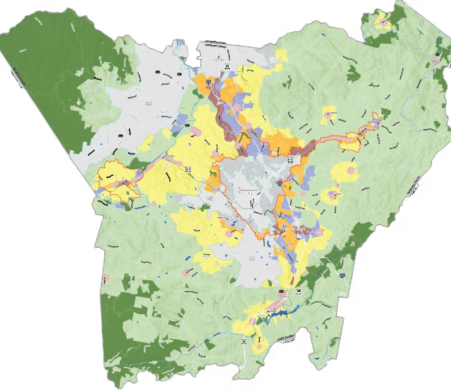
Attachmnent: Above is the Hendersonville 2045 Land Use Map
The following overview highlights ongoing, current, and past plans and studies connected to the Gen H Plan whether they are from the City of Hendersonville or Henderson County. It is assumed that the regulations, requirements, and standards will play a role in guiding the implementation of maps, general policies, and recommendations from the Gen H Plan. Collectively, these documents are intended to collaboratively influence future decisions regarding growth, conservation, character, or development within the City’s planning authority. Henderson County 2045 Comprehensive Plan was adopted in 2021. The Henderson County 2045 Comprehensive Plan outlines a vision for the community, shaping growth and development for the next 20 years. The plan was officially adopted on March 20, 2024, by the Board of Commissioners.
Gen H Highlights:
Parks and Greenspace Master Plan
The City of Hendersonville is developing a new citywide parks and greenspace plan to guide the development of a system that prioritizes equity and resilience. The updated Hendersonville Parks Master Plan will identify priorities and funding needs, assess staffing, and plan for future parks, greenspaces, and greenways. This aligns with the comprehensive plan, ensuring a coordinated approach to community development and recreational facilities.
Sustainability Strategic Plan (2024)
Hendersonville developed its inaugural Sustainability Strategic Plan, adopted by the City Council in May 2024. The plan outlines measurable goals and actions that integrate environmental, social, and economic values to reduce the City’s overall environmental impact, strengthen communities, and ensure a sustainable future for generations to come.
Plan Consistency
The Gen H plan is a framework to help the City of Hendersonville evaluate a variety of policy, regulatory, and public investment decisions. This assessment involves comparing proposed actions, investments, or decisions with the vision, principles, maps, policies, and recommendations outlined in the Gen H Plan.
DEVELOPMENT APPLICATION, REZONING
In adherence to state law, a rezoning application must include a statement of consistency with the Gen H Plan. The applicant needs to articulate their rationale for why their proposed zoning amendment is consistent with the currently adopted plan. To achieve consistency between its adopted comprehensive plan and the development decisions that applicants make, it will secure the power of private investment in service to advancing the community vision embodied in the Gen H plan.
PARTNERING ACTIVITIES
The City of Hendersonville will collaborate with public-private stakeholders to benefit the goals in the Gen H Plan involving local environmental conservation groups to preserve green spaces and enhance environmental sustainability. The City officials, when preparing resolutions in the future, seek to partner with conservation organizations to implement initiatives such as creating new parks, maintaining existing green spaces, or promoting environmental education programs. By citing consistency with the Gen H Plan, the City will demonstrate alignment through City resolution with its goals and actively engage in partnerships that contribute to the community’s overall growth and environmental health. The Gen H Plan adopted new community wide zoning ordinances reshaping the landscape of the City and surrounding areas.
Adoption of Zoning Ordinances Include:
Zoning Ordinance
The Zoning Ordinance regulates all land development within the City of Hendersonville and its extraterritorial jurisdiction (ETJ). Zoning Ordinance regulations correspond to the applicable zoning districts found in the City’s Zoning Map. It puts into effect policies from comprehensive plans, transitioning from suggestions to laws.
Flood Damage Prevention Ordinance
The City of Hendersonville participates in the National Flood Insurance Program. This allows residents of the City of Hendersonville and its jurisdiction to purchase flood insurance. The Flood Damage Prevention Ordinance regulates fill and encroachments within the flood hazard areas of the City. The purpose of this ordinance is to promote public health, safety, and general welfare and to minimize public and private losses due to flood conditions in specific areas based on the recent FEMA Floodplain Management and Protection of Wetlands Regulations To Implement the Federal Flood Risk Management Standard.
Minimum Housing Code Ordinance
The City of Hendersonville has adopted the Southern Building Code Congress International “Standard Housing Code” as the minimum housing code for the City of Hendersonville. The Minimum Housing Code Ordinance is adopted to provide for public safety, health and general welfare through structural strength, stability, sanitation, adequate light and ventilation and safety to life and property from fire and other hazards incidental to construction, alteration, repair, removal, demolition, use or occupancy of residential buildings and accessory structures.
The City of Hendersonville “Standard House Code” corresponds to the International Building Code and is in use or adopted in 50 states, the District of Columbia, Guam, Northern Marianas Islands, New York City, the U.S. Virgin Islands and Puerto Rico. As a model code, the IBC is intended to be adopted in accordance with the laws and procedures of a governmental jurisdiction.
Attachments: Below is the Future Land Use and Conservation 2045 Vision Map for Hendersonville Smart City Grid and the new ordinance chart.


The Local Government Committee for Cooperative Action (LGCCA)
Henderson County, the City of Hendersonville, the Town of Laurel Park, the Town of Fletcher, and the Town of Mills River, and the Village of Flat Rock, recognize the importance of fostering communication and joint planning between all entities. The LGCCA is effectively a whole-of-county approach to the “Smart Grid 15-minute City” concept.
The Local Government Committee for Cooperative Action (LGCCA) was established by local governments to improve communication and planning between the County and its municipalities. The LGCCA believes it can enhance communication and planning by discussing and studying certain types of land use planning and the effect of the proposed land use change on the entire community, not just on the entity suggesting the change.
Local Government Committees Include:
Henderson County Tourism Development Authority (TDA)
The Tourism Development Authority (TDA) was formed by North Carolina Session Law to administer the expenditure of occupancy taxes collected for the purpose of promoting tourism in Henderson County.
The Diversity and Inclusion Advisory Committee
The Diversity & Inclusion Advisory Committee serves to offer insight and direction towards the City Council’s strategic goal of fostering equity, inclusion, and a sense of belonging, while also rectifying historical inequalities and ensuring respectful treatment for all individuals. While the committee operates under the terms outlined in its charter, any conflicts between the charter and North Carolina Law defer to the laws of the state.
Agriculture, Green Space and Conservation Committee
The Conservation Committee suggests a more compact form of development which concentrates uses in a smaller geography. The result is less pressure to convert farmland and open space into new development. Allowing more density in key locations within the community will delay the expansion of the development footprint and allow time for open space conservation initiatives to effectively establish protections.
The City in collaboration with Henderson County and rural farmers commits to protecting the working landscape of farms, forests, and orchards, and guide growth to areas with suitable infrastructure. A collaborative process established with the County and rural farmers with the goal of protecting the working landscape of farms, forests, and orchards, and guide growth to areas with suitable infrastructure.
Below is the Local Government Committee for Cooperative Land Use Map for the neighboring Henderson County communities adopting the 2045 shared “Greenway Network” plan.

The Countywide '15-Minute Smart City’ Grid
Utilize existing Mixed Use Zoning Districts
Hendersonville will introduce multi-family housing in commercial corridors and redevelopment areas. Support the production of multi-family housing units in commercial corridors and redevelopment areas through the City’s existing mixed use zoning districts to support implementation of the Future Land Use and Conservation Map.
Implement Top Projects from The Affordable Housing Strategic Plan
Support the production of more affordable housing by implementing the top projects in the City’s new Affordable Housing Strategic Plan. Strategies may involve creating a Housing Trust Fund, working with institutional partners and using development standards to catalyze affordable housing development (e.g. expand housing types, incentivize affordable housing, update conditional zoning standards), working with selected neighborhoods (e.g. Green Meadows) to develop a community land trust to protect and develop affordable housing, studying publicly owned land for affordable housing, and assisting property owners as micro developers. BlueRidgeNow reports “The Seventh Avenue District has historically consisted of African American communities, including Green Meadows, which was known until 1972 as Brooklyn. The name changed when Hendersonville's "urban renewal" project in the 1960s and 1970s pushed residents out and leveled existing homes, which were replaced with a low-income housing complex.” Multifamily housing is already allowed in zone C-2, which “typically only allows single or two-family residents and minor planned residential developments, within the 7th Ave Depot National Register Historic District. The proposed change would expand the exception to the much larger 7th Avenue MSD, unifying codes between the two.”
The Affordable Housing Strategic Plan consists of supporting development proposals that mix subsidized housing with market-rate housing. Encourage mixed-income and market rate development to boost affordable housing production.
Healthy and Accessible Natural Environment
Update green space protection standards as part of new UDO to promote access and prioritize type and quality of green space protected with new development of green space standards for new projects that clarify the preferred type and characteristics of land to be protected or dedicated, and that promote local access to this resource.
Update floodplain development standards, including increasing freeboard requirements, strengthening redevelopment standards for new development and redevelopment to identify potential updates to reduce flood risk and damage. Existing and planned open spaces through the “Healthy and Accessible Natural Environment” initiatives requirements in new development and redevelopment, and land acquisition programs.
Integrate Natural Resources requirements in zoning ordinance with floodplain requirements as part of the new United Development Ordinance (UDO): Combine the development standards for natural resources and floodplain protection as part of drafting a new UDO.
Safe Streets and Trails
Work to improve pedestrian safety and convenience by pursuing projects from the new Walk Hendo. New trail projects and other initiatives such as the Ecusta Trail necessitate an update to the 2017 Hendersonville Bike Plan to reflect a changing bike network. As a result, request grant monies from the N.C. Department of Transportation to fund this work is underway. Use local funding as a match to pursue state and federal funding for transportation projects will necessitate the completion of the project. Other actions include identify road safety projects to help reduce and eliminate serious accidents and deaths by collaborating with local, regional, and state partners on infrastructure improvements to create safer streets. The Safe Streets and Trails initiative abides by Secretary Pete Buttigieg’s mandate of reducing automobile accidents to zero through the DOT National Roadway Strategy initiative.
The Hendersonville Gen H 2045 plan is designed to leverage the development pattern and introduce feasible alternatives to automobile travel including public transit investments supporting the new zoning codes.
Green Energy Pursuit
Hendersonville will pursue renewable energy and energy efficiency improvements to increase the use of clean energy as a percentage of overall energy needs and engage partners on options.
The Vision Map Zoning City and Outside City Boundaries Zoning
The Vision Map is meant to provide a framework for future land use decisions and offers additional guidance with respect to the application of land development regulations (e.g., zoning and subdivision), the provision of services, and the prioritization of capital investments in support of the future development pattern of the countywide vision. The area is comprised of the City Limits - the areas within the City’s boundaries where it has full authority, the Extraterritorial Jurisdiction (ETJ) - the areas that lie outside the City Limits but are still subject to City planning and zoning regulations, and the City/County Joint Planning Area - unincorporated County areas outside of the City boundaries and are governed by Henderson County. The Vision Map utilizes the Comprehensive Transportation Plan (CTP) for French Broad River MPO, which serves as the vision for the future transportation system.
Hendersonville has award funding to help with the Gen H plan development by securing $4.5 million from the American Rescue Plan Act (ARPA). Hendersonville has also been awarded $3,418,165 in grant money that will help reduce flood risk and restore floodplains in Hendersonville’s southside. The above funding is not an exhaustive list of all federal, state, and matching grant awards from non-governmental organizations. This past July, the Hendersonville City Council adopted a $62.8 million budget that raises the property tax rate.
Henderson County Board of Commissioners’ Chairman Rebecca McCall declared a State of Emergency for Henderson County on September 26, 2024, from hurricane Helene. Areas of Hendersonville also received flood damage from hurricane Helene. Unfortunately, the City entered into funding agreements for the Gen H 2045 community development vision. The Gen H development countywide future development plan might explain why property owners are not receiving financial assistance to help rebuild their damaged property. But there is hope.
Recommended Actions To Course Correct
Several weeks ago, A Washington D.C. District Court of Appeals ruled that the White House Council on Environmental Quality (CEQ), established to instruct agencies on NEPA compliance, does not have the power to issue regulations on other federal agencies as it has since 1970, Marin Audubon Society v. Federal Aviation Authority. The National Environmental Policy Act plays a big part in compliance and implementation of the FEMA floodplain rules through existing procedures including the President’s Council on Environmental Quality (CEQ) Executive Task Force. The CEQ Climate and Economic Justice Screening Tool is then used by all other agencies when determining Environmental Impact, regulations, mitigation and subsequent Federal Register final rule changes.
City and County officials are unlikely aware that they have been overtly defrauded. Local residents need to encourage city authorites to unite and sue for fraud. Fraud evicerates a contract agreement. Unless challenged, writ large, the severability clause will take affect. In determining severability, if “a contract covers several subjects, some of whose provisions are valid and some void, those which are valid will be upheld if they are not so interwoven with those illegal as to make divisibility impossible.” Alston Studios, Inc, v. Lloyd V. Gress & Assocs., 492 F.2d 279, 285 (4th Cir. 1974), Tactical Rehab. v. Youssef, 2:24-cv-173, 30-31 (E.D. Va. Nov. 7, 2024).
Work with your Mayor, city council, and their lawyers to restore the original municipality charter, by laws, ordinances that binds the decisions of your local community.
All my reporting is completely voluntary, please consider a paid subscription to Andrea’s News Letter or consider a one-time donations to my "Buy Me a Coffee account. My purpose is to educate the public on government overreach and provide solutions that will secure the core values of our country; Life, Liberty and the Pursuit of Happiness. God Bless.